A exposição online «Macau: diferentes olhares em tempos diferentes. Fotografias de Raquel Soeiro de Brito e da colecção do Centro Científico e Cultural de Macau» é uma iniciativa conjunta do Centro de Estudos Geográficos do Instituto de Geografia e Ordenamento do Território da Universidade de Lisboa (CEG-IGOT-ULisboa) e do Centro Científico e Cultural de Macau (CCCM, I.P.). Pretendeu-se colocar em diálogo uma série de fotografias de Macau obtidas no início da década de 1960 pela geógrafa Raquel Soeiro de Brito com um conjunto de imagens do mesmo território realizadas por quatro fotojornalistas que fixaram a fisionomia de Macau ao longo dos anos 1980 e 1990.
Raquel Soeiro de Brito, destacada geógrafa da «escola de Geografia de Lisboa» da segunda metade do século XX, realizou a sua primeira missão de estudo a Macau em 1961, quando era investigadora do CEG-ULisboa. Esta exposição é construída a partir de uma selecção de 90 imagens retiradas da série de mais de 300 fotografias e diapositivos dessa viagem realizada há 60 anos, pertencentes à Fototeca do CEG. São imagens de uma cidade com pouco mais de 150.000 habitantes, ainda muito marcada pelas actividades marítimas, pela horticultura chinesa nas áreas recém-conquistadas ao mar, na sua periferia leste, e pela sobrevivência de espaços intersticiais não completamente urbanizados. Nos grandes planos que fixam o quotidiano da população, o olhar fotográfico da geógrafa surpreendeu a duradoura imutabilidade do mundo tradicional chinês que reencontramos nas fotografias dos principais nomes que tinham feito a reportagem da China ou de Macau – de Felice Beato a John Thomson, de Leone Nani a José Neves Catela, entre tantos outros.
Na altura em que Raquel Soeiro de Brito conheceu e estudou a geografia de Macau pela primeira vez, acabara de transcorrer o décimo aniversário da proclamação da República Popular da China (1949) e a então colónia portuguesa ensaiava um novo modelo de desenvolvimento, assente no turismo de jogo e no aproveitamento da dinâmica industrial de Hong Kong. Momento charneira na história do território, deixará marcas nas primeiras expansões urbanas e na melhoria das ligações com as ilhas da Taipa e Coloane e com o hinterland chinês. Esta transformação urbana será substancialmente acelerada pela dinâmica de descolonização aberta pela revolução portuguesa de Abril de 1974 e, quase em simultâneo, pelo início das reformas económicas chinesas da época pós-maoísta.
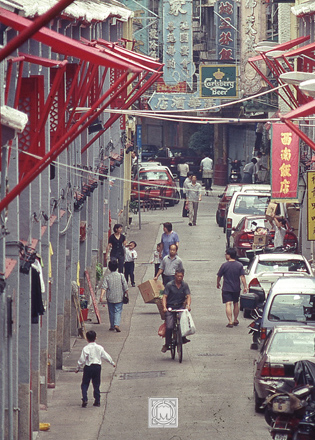
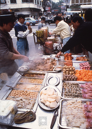
Escolhemos ilustrar a nova face que Macau foi ganhando ao longo dos últimos 25 anos do século XX com recurso a um conjunto de 66 fotografias pertencentes ao acervo do Centro Científico e Cultural de Macau. Fruto sobretudo da actividade de fotojornalistas que trabalharam em Macau nas décadas de 1980 e 1990, estas fotografias integram um núcleo de cerca de 5000 imagens de proveniência muito diversa, mas desde logo tornado coerente pelo critério do jornalista e editor Rogério Beltrão Coelho, que em boa medida o reuniu. Desse conjunto, seleccionaram-se fotografias de Álvaro Tavares, Eduardo Tomé, Cheong Io Tong e do próprio Rogério Beltrão Coelho, as quais foram distribuídas pelos quatro núcleos que estruturam toda a exposição: enquadramento da cidade, o pormenor das ruas e das gentes, os espaços rurais periféricos e, por último, as áreas portuárias e a pesca, a actividade exportadora mais importante do território até à II Guerra Mundial.
Se todas as fotografias cristalizam uma fracção do tempo no espaço, nesta sucessão de imagens, e na grelha de leitura geográfica que as organiza, lê-se também muito bem como a aparência física de um lugar como Macau se pode alterar bruscamente, a ponto de fazer das primeiras fotografias quase um vago vestígio arqueológico das mais recentes. Mas já outra coisa se poderá dizer sobre o cromossoma desse lugar, que nos gestos quotidianos e nos usos intensos da cidade – onde tantas vezes a rua é apenas uma extensão da casa – parece manter ainda muitos dos ambientes e dos ritmos de sempre. Último sopro de um tempo longuíssimo? Outras fotografias mais recentes, a reunir em outra exposição no futuro, ajudarão a responder a esta pergunta.
The online exhibition Macao: different visions at different times. Photographs by Raquel Soeiro de Brito and the Macau Scientific and Culture Centre Collection is a joint initiative of the Centre for Geographical Studies of the Institute of Geography and Spatial Planning, University of Lisbon (CEG-IGOT-ULisboa), and the Macau Scientific and Cultural Centre (CCCM, P.I.). This exhibition aimed to put into dialogue a series of photographs of Macau taken in the early 1960’s by the geographer Raquel Soeiro de Brito with a series of images of the same territory taken by four photojournalists who portrayed the metamorphoses of Macau throughout the 1980’s and 1990’s.
Raquel Soeiro de Brito, renowned geographer of the so-called Lisbon Geographic School in the second half of the 20th century, carried out her first fieldwork mission to Macau in 1961 when she was a researcher at the University of Lisbon’s Centre for Geographical Studies. This exhibition brings together a selection of 90 pictures taken from a series of over 300 photographs and slides from that fieldtrip held 60 years ago, which are part of the CEG’s Photo Library. These are images that portray a city of just over 150,000 inhabitants where maritime activities and Chinese horticultural practices in eastern areas recently conquered from the sea still prevailed and where interstitial spaces were not yet entirely urbanized. In close-ups photographs that illustrate daily life elements, the geographer’s photographic gaze surprised the same enduring immutability of the traditional Chinese world that we can find in the photos taken by the pioneering photographers of China and Macau, namely Felice Beato, John Thomson, Leone Nani and José Neves Catela.
When Raquel Soeiro de Brito visited and studied the geography of Macau for the first time, the tenth anniversary of the proclamation of the People’s Republic of China (1949) had just passed. At the time, the Portuguese colony was testing a new model of economic growth based on casino tourism and Hong Kong’s industrial supremacy. Such structural change represented a pivotal moment in the history of Macau and induced large land reclamation projects and the improvement of the networks between Macau and the islands of Taipa and Coloane and with the Chinese hinterland. Such urban transformations were further accelerated by the decolonization process triggered by the 1974 Carnation Revolution in Portugal and, almost concurrently, by the beginning of the Chinese economic reforms in the post-Maoist period.
We decided to illustrate the new image that Macau achieved over the last quarter of the 20th century through a set of 66 photographs from the Macau Scientific and Cultural Centre’s collection. Largely due to work undertaken by some photojournalists in Macau during the 1980s and 1990s, this set of images were taken by Álvaro Tavares, Eduardo Tomé, Cheong lo Tong and Rogério Beltrão Coelho and belong to a series of about 5000 photographs gathered by the journalist and editor R. Beltrão Coelho. These photographs were distributed by the same sections that structure the entire exhibition: city framing, details of the streets and people, peripheral rural areas and, finally, seaport areas and fishing, which was the most important export activity in Macau until World War II.
While all the photographs shape a fraction of time in space, in this sequence of images and in the geographic grid that organizes them, it is possible to recognize how the physical appearance of Macau changed to the point where earlier photographs seem like a vague archeological artifact of the more recent ones. But something else can be stated about the chromosome of this place, where daily routines and some intense urban usages – such as those habits that make the street a mere extension of the house – appear to preserve undying ambiences and rhythms. Was it the last breath of an enduring time? Other and more recent photographs may help answer this question in a future exhibition.
网上展览《澳门在不同时期的不同愿景》由拉克尔·索埃罗·德·布里托(Raquel Soeiro de Brito)及澳门科学文化中心收藏,是里斯本大学地理和空间规划研究所的地理研究中心(CEG-IGOT-里斯本大学)和澳门科学文化中心(CCCM, 公立学院) 的联合倡议。这个展览旨在将地理学家由拉克尔·索埃罗·德·布里托(Raquel Soeiro de Brito)于1960年代初期拍摄的一系列有关澳门的照片与四位摄影记者于1980年代和1990年代拍摄的同一地区的照片进行对话,它们描绘了澳门的变化。
拉克尔·索埃罗·德·布里托Raquel Soeiro de Brito) 是20世纪下半叶里斯本地理学派的著名地理学家。1961年她在里斯本大学地理研究中心担任研究员时,首次前往澳门进行实地考察。该展览是从60年前那次旅行的300多张照片和幻灯片中精选出的90张照片组成,是CEG照片图书馆的一部分。这些图像描绘了一个刚刚超过15万居民人口的城市,那里的空间尚未完全城市化,海洋活动与最近从海上征服的东部地区的中国园艺实践仍然盛行。在捕捉民众日常生活的特写镜头中,地理学家的摄影眼光让我们惊讶于中国传统世界的持久不变性。我们可以在费利斯•贝托 (Felice Beato),约翰•汤姆森(John Thomson)、莱昂•纳尼(Leon Nani)和若瑟•利维士•嘉德礼(José Neves Catela)等先驱摄影师所拍摄的照片中发现这一点。
当拉克尔·索埃罗·德·布里托(Raquel Soeiro de Brito)第一次了解和研究澳门地理时,中华人民共和国刚刚宣布成立十周年(1949年)。那时,葡萄牙的殖民地正在试验着一种基于博彩旅游与香港工业优势的新经济增长模式。这种结构的变化代表了澳门历史上的一个关键时刻,并促进了大型填海工程,改善了澳门半岛、氹仔岛、路环岛,以及中国内地之间的网络。1974年葡萄牙的康乃馨革命所引发的非殖民化进程,以及几乎同时发生的后毛泽东主义时代的中国经济改革的开始,都进一步加速了这种城市转型。
我们选择通过澳门科学文化中心收藏的66张照片来展示澳门在20世纪的最后25年里所获得的新形象。这些照片是20世纪80、90年代在澳门工作的摄影记者的工作成果。 它们是一组约5000张图片的一部分,来源非常不同,但均由编辑古维杰(Rogério Beltrão Coelho)酌情收集。其中阿尔瓦罗•塔瓦雷斯(Álvaro Tavares)、爱德华多•托梅(Eduardo Tomé)、张耀棠(Cheong Io Tong)和古维杰(Rogério Beltrão Coelho)本人的照片被选中,并按照构成整个展览的四个核心部分分布:城市框架、街道和人民的细节、周边农村地区、最后是海港地区和渔业,这是澳门在第二次世界大战前最重要的出口活动。
虽然所有的照片都只塑造了空间中的一小部分时间,但在从这一连串的图象与组织它们的地理网格中,我们可以了解到澳门外观的变化,以至于早期比近期的照片看起来像一个模糊的考古学文物。但是,关于这个地方的特色,还可以说些别的东西。这里的日常生活,还有一些强烈的城市习惯,比如那些把街道变成房子延伸的习惯,以及仍然保持着过去的气氛和节奏的习惯。这可能是时代永恒的最后一口气吗?其他更近期的照片可能有助于回答这个问题,它们将在未来的另一个展览中汇集。